

Lagos floods disrupted businesses, shut an airport terminal, and alarmed coastal states on Tuesday as Nigeria faces peak flood season from July to September.
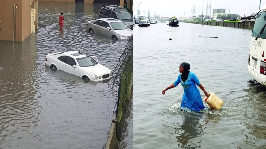
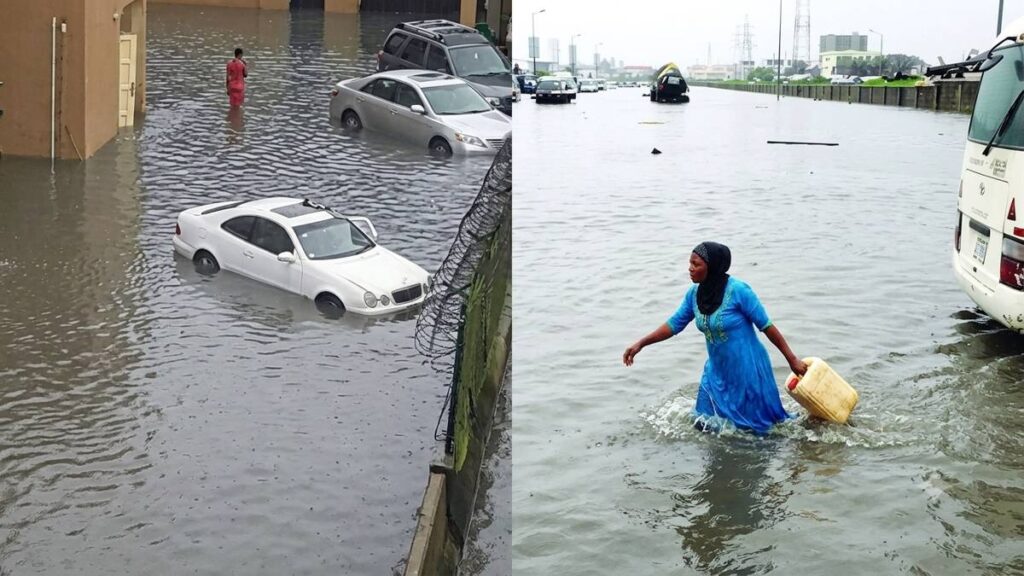
Floodwaters swallowed Lagos whole on Tuesday. Roads vanished. From Lekki and Ajiran on the Island to Oshodi, Gbagada, Ikeja, and Ikorodu on the Mainland, streets had become rivers, trapping commuters in hours-long gridlock and submerging homes and shops.
It was the first day of peak flood season. Nigeria’s July-to-September window had opened, and Lagos felt it immediately, with businesses shuttered, commuters stranded, and an airport terminal forced to suspend operations before midday.
Water breached the Murtala Muhammed International Airport’s temporary international terminal, inundating the departure hall, boarding gates, and airline offices. The Federal Airports Authority of Nigeria suspended operations there. Floodwaters had reportedly reached the terminal’s powerhouse.
Air France-KLM, Ethiopian Airlines, and Fly Gabon relocated to Terminal Two. No flights were cancelled. FAAN Director of Public Affairs Henry Agbebire told reporters the flooding was localized and linked to ongoing construction activities affecting drainage.
Markets in Oshodi and Ikotun were swamped by mid-morning, traders wading through stalls to rescue what stock they could before the water climbed higher. But many lost the fight. Business owners are now counting losses that may take months to recover.
Titilope Adebayo runs a business in Oshodi. She confirmed by phone that customers stayed away until the water receded. “It was not just inconvenience,” she told Westtrybe on Wednesday. “Goods were damaged and customers vanished.”
Yet the Lagos State Ministry of Environment and Water Resources carries a 2026 budget of N236 billion. Residents still waded through knee-deep floodwaters. Schoolchildren were ferried by boats, and an airport terminal went dark.
Lagos State received more than N1.25 billion in ecological fund allocations between January and May 2026, as gathered by Westtrybe from data obtained from the Office of the Accountant-General of the Federation. Monthly disbursements ranged from N186.9 million in February to N299.57 million in April, totaling N1.253 billion across five months.
Lagos State Commissioner for Environment and Water Resources Tokunbo Wahab wrote on X on Monday that the flooding was largely a flash flood triggered by several hours of intense rainfall. Water levels, he noted, had receded in many affected areas by evening.
He explained that high lagoon water levels can temporarily block stormwater drainage until the tide subsides.
Social activist Scot Iguma rejected that framing at a briefing in Lagos. He was direct. “The flooding that we’ve been seeing recently is not normal,” Iguma stated. “It is no longer just flash flooding but an existential threat.”
Flooding has affected 52,013 people in Lagos State alone in 2026. Nationwide, NEMA reported 231 deaths, with 315,762 people affected, 113,367 displaced, 40,493 houses damaged, and 46,304 hectares of farmland destroyed across the country.
And the economic toll keeps rising. World Bank estimates and other international organizations put flooding, damaged infrastructure, and lost productivity at as much as $4 billion annually to the Lagos economy alone.
Bayelsa, Cross River, Delta, Lagos, Ogun, Rivers, and Ondo face coastal flooding driven by rising sea levels and tidal surges. The federal government’s 2026 Annual Flood Outlook warns of cascading impacts on fishing, wildlife habitation, and river navigation across all seven states.
NiMet’s 2026 Seasonal Climate Prediction, released in February, forecast above-normal rainfall across Lagos with a delayed end to the rainy season. Annual precipitation could reach 2,010mm in the Badagry Division, with an average of 1,965mm projected across the state’s 20 local government areas.
NEMA’s Lagos Territorial Office separately flagged Badagry, Epe, Alimosho, Ikeja, and Surulere as flash flood zones. Ikorodu and Isheri face a different risk entirely: rising water levels linked to possible releases from the Oyan Dam between July and October.
During a flood preparedness sensitization program in May, LASEMA Permanent Secretary Dr. Olufemi Oke-Osanyintolu described Lagos as a coastal megacity with over 22 million residents and extensive waterways. “While this drives economic growth, it also exposes us to recurrent flooding,” he said.
“Response alone is no longer sufficient.
The Federal Ministry of Environment identified fifteen high-risk flood zones across Lagos, including Apapa, Badagry, Epe, Eti-Osa, Ikeja, Ikorodu, Ikoyi, Lagos Island, Lekki, Ojo, Orile-Agege, Surulere, Agege, Alimosho, and Kosofe. Every one of them is now at elevated risk.
Sunday’s downpour did more than flood streets. A two-story building collapsed in Mushin. In Shogunle on the Oshodi axis, a section of the Nigerian Air Force base fence, weakened by floodwaters, collapsed onto vehicles and caused additional damage.
By Tuesday, some communities had begun to drain. But NiMet renewed its alert, warning residents of continuous rainfall and heightened flood risks across Lagos and other coastal states, advising motorists and pedestrians to avoid driving or walking through floodwaters.
Peak danger runs from July to September 2026, coinciding with expected water releases from the Lagdo Dam in Cameroon. That window is now open. What hit Lagos on July 1 was not an anomaly; it was a signal of what coastal states, already stretched thin, will face in the weeks ahead.